The New Addis Ababa Master Plan Design
Addis Abeba's 10th Master Plan Sees 13 Districts
The new plan, which includes a focus on socio-economic aspects of the city, will have a separate office to ensure its efficient implementation.

Addis Abeba's 10th Master Plan Sees 13 Districts

total_area_addis_abeba_map

Addis Abeba's 10th Master Plan Sees 13 Districts
‹ ›
Two years after Addis Abeba's ninth master plan was phased out, the tenth master plan, integrating socio-economic aspects of Ethiopia's capital city, is now officially out for public discussion. This comes soon after the controversial integrated Addis Abeba & Surrounding Oromia Special Zone Integrated Master Plan was cancelled. The new master plan has been developed by the newly renamed Addis Abeba City Planning Project Office.
Less the specialised Oromia special zone, the proposed 1.1 million hectares of land outside the capital has now been reduced back to just 52,000ha.
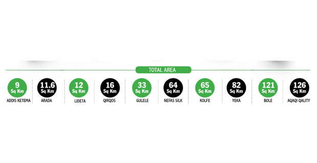
Though the area of the land has been scaled back, the number of districts is proposed to reach 13, dividing each of the existing three, considered too big for a standard, into two.
Yeka, Aqaqi Qality and Bole will be twinned to six different districts.
A proposal for the establishment of a dedicated body – the Addis Abeba Planning Commission – to oversee and coordinate the implementation of the plan is a development.
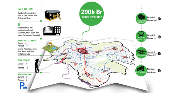
The office will also be mandated to manage the implementation budgeting and mobilisation of the master plan. It is estimated that the whole project will cost over 290 billion Br.
During its 130-year history, Addis Abeba has seen various plans, mainly by foreign companies, the first from the period of the brief Italian occupation.
The only plan to take areas beyond the capital into consideration and adjust plots came back in the 1950s. At that time, the plan was developed by Sir Leslie Patrick Abercombie. It was, however, ultimately never implemented.
The new plan is guided by the vertical expansion principle of city development, as opposed to horizontal expansion. It includes the following major tenants – redevelopment, compact settlements and developing integrated plans, in terms of transport, housing, and the social and economic sphere.
In this respect, six sectors have been selected – transport, housing, environmental protection, industry, development and recreational centres – as focal points.
The transport sector, steered by mass transportation prioritisation, will see the expansion of the Addis Ababa Light railway system – extending its routes with Ayat to Tafo Square, St George Church to Sheromeda, Tor Hayloch to Jemo and Qality to Aqaqi. A new Rapid Bus Transit lane exclusive to public transport will also be developed, alongside the manufacture of dedicated buses. All of these projects seek to boost the implementation of Addis Abeba's mass transportation system.
Out of the nine Rapid Bus Transits proposed, one corridor, B2, is already underway. The 16km lane will stretch from the Pasteur Institute to the Jemo Condominiums. The remaining eight corridors, which will cover 93km, are proposed to be completed within the given timeline. A company from France is currently conducting a detailed design study of the B2 corridor.
In order to also accommodate for private transportation, 60 vertical car parks have been envisioned to help ease the space congestion issue in the city. Though yet to be discussed and approved, the city has started to implement the project. The sites for twenty of these have already been identified. Just recently, the city awarded contracts to two companies to construct seven automated structures and one surface parking structure. These two alone cost the city close to 64 million Br.
The bold mission to build one million houses during the master plan period is projected to help solve the city's underlying housing problem. This plan goes in line with the five million new residents the city is projected to have over the coming ten years.
The new sites identified for these massive housing projects are mainly situated on the peripheries of the city, including Koye Fitche, Bole Arabsa and Yeka.
In the inner city area too, shanties will be cleared to accommodate close to 400 thousand new houses. During previous redevelopment programmes, residents were located far from their original habitat, but now there are few vacant spaces left. Thus, displaced residents must be resettled in nearby areas, Tamrat Eshetu, Land Use & City Structure Team Leader, told Fortune.
The tenth master plan has stressed a list of recommendations that must be followed during its implementation.
The plan recommends that the residents included under this programme should be informed of its timeline. Again, the residents have to be compensated with new homes located in the same area that the redevelopment takes place, or relocated within a one-kilometre radius.
In transferring constructed condos, the plan has also indicated that priority has to be given to those who have lost their original shelter and should not be put into a lottery lot.
The capital will have its city centres across eight locations, including the National Theatre, Cherqos, Filwoeha-Mesqel square, La Gare, Kazanchis and Churchill. A total of 335ha of land is dedicated for this plan, which will be finalised over the coming five years. Areas of Cherqos and Filwoeha-Mesqel Square, amounting to 120ha and 90ha, respectively, will be turned into parks, exhibition centres, offices and malls.
This is just for category one city centres. Close to 14 additional centres will be located across 850ha of land within categories two and three. Yet another 300ha of land will also be dedicated at the wereda level.
In a bid to accelerate the services sector of the city, as a special project, two international standard hospitals, in Bole Arabsa and Meri Loqe, five five-star and above hotels and two stadiums, in Gerji and Lebu, will be installed. The hotels will be located in areas like Old Airport, Sar Bet, Mexico and Kazanchis. In addition, a hotel will be installed at Entoto during the second five years of the plan.
Some space behind Bole International Airport will be left vacant for a golf course. Private engagements are also recommended throughout the whole initiation of the services sector.
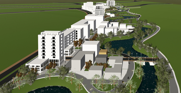
Rivers, river basins and areas vulnerable to drainage issues will be covered with plants and transformed into parks. Along these lines, 170 spots have been identified at the city, district and wereda level to serve as parks. Rivers, such as Kebena, Bant Yeketu and Kechenea, which stretch 33km, will be developed.
Most of green areas that were left are now being utilised for public projects, predominantly housing. This is mainly due to budget and capacity constraints of offices dedicated for this purpose, said Tamrat.
Those individuals currently settled in the river and river basin areas, and the more vulnerable areas of Entoto, Gulele, Lebu and Repi, will be resettled.
Published on Jul 12,2016 [ Vol 17 ,No 845]
SHARE :
Editorial

With a reformist administration in charge of the executive, there has b...
Agenda

The new electricity tariffs that became effective on December 1, 2018,...
Fineline
Who it is that midwifed the rapprochement between E...
Commentary

Egyptian companies are about to sue the federal government over their i...
Viewpoint

A recent photo between Prime Minister Abiy Ahmed (PhD) and George Soros...
Opinion

The future is bleak. Millennials and younger generations who will inher...
View From Arada

There is heated debate on the propriety, decency and morality of breast...

Business Indicators

ADVERTISEMENT
Editors Pick
- Popular
ADVERTISEMENT

ADVERTISEMENT

ADVERTISEMENT
SUBSCRIBE TO ADDISFORTUNE
![]()
![]()
![]()
![]()
![]()
ADVERTISEMENT
The New Addis Ababa Master Plan Design
Source: https://addisfortune.net/articles/addis-abebas-10th-master-plan-sees-13-districts/
0 Response to "The New Addis Ababa Master Plan Design"
Post a Comment